Better Prediction of Extreme Weather Events
Project of the St. Pölten University of Applied Sciences Investigated Forecasts of Extreme Weather Events Using Mobile Radio Data

In the project “LINK”, researchers of the St. Pölten UAS examined how the use of microwave links of the already existing mobile radio network can be used to predict extreme weather events. Emergency response organisations as well as the civilian population would benefit from this when it comes to the implementation of measures for damage prevention.
In many parts of Europe, we experienced a very dry winter this year. Due to climate change, more and more extreme weather events are occurring. Short-term forecasts that are as accurate as possible in terms of time and location would be a major advantage for taking appropriate measures to prevent damage and for reacting and planning more efficiently. Above all, the civilian population and emergency response organisations would benefit from this.
Short-term forecasts require a very dense network of ground stations and remote sensing systems such as weather stations, weather radar, and satellites to provide up-to-date weather data. In the project “LINK – Analysis and Nowcasting of Extreme Events”, researchers at the St. Pölten UAS are using physical data from directional radio links, such as those used for mobile telephony, to obtain information about the current precipitation situation.
“The project LINK has shown that by applying machine learning methods and using commercial directional radio data, a temporally and spatially accurate prediction of rain events in Austria (even in impassable terrain) is possible. These results can help to reduce damage caused by extreme weather events and improve the effectiveness of damage prevention measures”, emphasises Oliver Eigner, project leader and researcher in the Department of Computer Science and Security at the St. Pölten UAS.
Analysis of Directional Radio Data
Due to the steady expansion of the mobile communications network, data on the physical properties of microwave links are available in large quantities and largely cover the entire area. The data used were provided by the project partner Hutchison Drei Austria and consisted of over 4,500 commercial microwave links. In the project, researchers investigated the usability of this microwave radio relay data for forecasting extreme weather events. Artificial intelligence (AI) methods, in particular machine learning, were used to create a model.
Model for Precipitation Estimation
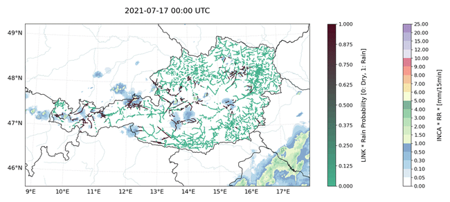
 Animation: To show the model in action, the researchers chose 17 July 2021 as an example (test data), which was a severe thunderstorm weekend in Austria. The figure shows the microwave links of the predefined area, coloured between 0 and 1, based on the initial probabilities of the positive class and above it the actual observed precipitation as radar data.
Oliver Eigner's team developed a model in which commercial microwave links can be used to estimate the current precipitation situation using traditional machine learning approaches.
“The results of the model are quite impressive and show the great possibilities in using microwave links to estimate the current precipitation situation”, Eigner is pleased to report.
Cooperation Partner
LINK was developed in cooperation with GeoSphere Austria (formerly ZAMG), which provided the weather data and assimilated the model results into numerical weather models. The project partner Hutchison Drei Austria provided the commercial directional radio data as well as know-how on the mobile network side. The hydrography of the Province of Styria, as the consumer, provided knowledge about extreme weather events and the resulting countermeasures to be taken.

Dipl.-Ing. Oliver Eigner , BSc
Coordinator AI and Digital TransformationService and Competence Center for Higher Education Development and Quality Management Researcher IT Security (BA) Department of Computer Science and Security