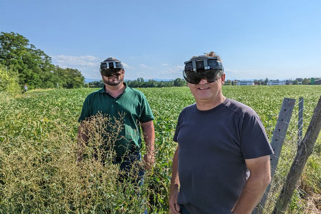
The Future of Smart Agriculture
Research Project of BOKU University and St. Pölten UAS Revolutionises Agriculture with Augmented Reality Technologies

The joint research project ARmEO (Augmented Reality meets Earth Observation) of BOKU University and the St. Pölten University of Applied Sciences makes satellite-based data more accessible, usable, and effective for farmers and other groups. Thanks to satellite-assisted tools and the application of Augmented Reality technologies, the project helps make agriculture more sustainable and efficient.
The history of agriculture is characterised by change. Modern measuring techniques such as field and machine sensors, analysis tools for the use of big datasets, and satellite data are already available. Decisions regarding the use of fertilisers or plant protection agents, the timing and extent of irrigation, and the sowing of seeds can thus be carried out on the basis of various data sources.
Augmented Reality Technologies for Visualisation of Satellite Data
The researchers in the project ARmEO (Augmented Reality meets Earth Observation) developed a user-friendly and cost-effective solution for combining satellite-based information and Augmented Reality (AR) technologies for smart agriculture. The undertaking focused on the use of innovative AR visualisation methods that assist people in overcoming specific agricultural challenges through a novel way of visualisation and digital information.
“Digital information and its local origin in the world are still usually examined as two separate things, which is why their potential for agriculture often remains unexploited. The reasons for problem areas in the field remain unclear, and the systematic improvement of this situation requires expensive and specialised equipment. The direct visualisation of data in the field using AR, which involves merging real conditions with abstract, digital information, accelerates the process of gaining an understanding tremendously and will become usable for everyone in the future as AR glasses become more widespread”, emphasises Matthias Husinsky, project co-head and lecturer at the St. Pölten UAS’ Department of Media and Digital Technologies.
Revolution for Smart Agriculture
ARmEO has the potential to revolutionise smart agriculture. It makes satellite-based data more accessible and their use more effective for farmers and other groups. The project’s results can contribute to more sustainable and targeted agricultural practices. At the same time, the joint use of data promotes collaboration and the exchange of knowledge within the agricultural community.
“As a scientist, I no longer have to juggle with data and fieldwork”, states Francesco Vuolo from the Institute of Geomatics at BOKU University. “With ARmEO, we were able to design an Augmented Reality prototype that directly provides us with information. With this innovative tool, users can seamlessly access the data during the collection of samples, which makes work in the field more efficient and exact than ever.” Vuolo adds that he is excited for the continued availability of ARmEO and is already involved in its further development in order to extend the boundaries of what this transformative technology can do.
Practical Application for Farmers
By developing a prototype for the visualisation of satellite maps in the area of agriculture using the Microsoft HoloLens 2, it was possible to improve the user experience for the application of spatial data. In addition to the researchers, farmers themselves also tested the use of AR glasses.
In addition to AR visualisation, tools for plant comparison by means of time series of Copernicus Sentinel 2 satellite data were also developed. This allows farmers to compare the growth curves of individual land plots to those of neighbouring plots that have similar soil and climate conditions.
Moreover, the researchers developed an algorithm for drawing up a map of the yield potential. For the first time ever, this map can be combined with official nitrogen regulation data in order to use fertilisers more efficiently.
About ARmEO
The cooperation project ARmEO received funding from the Austrian Research Promotion Agency (FFG) within the framework of the Austrian Space Applications Programme (ASAP 16). ASAP 16 is a funding programme that supports the development of innovative space-assisted solutions for terrestrial applications. It is financed by the Austrian Federal Ministry for Climate Action, Environment, Energy, Mobility, Innovation and Technology (BMK) and managed by the FFG.
The ARmEO project consisted of a consortium of three Austrian organisations – the Institute of Geomatics at University of Natural Resources and Life Sciences (BOKU University) in Vienna, the Department of Media and Digital Technologies of the St. Pölten UAS, and AGROservice (an agricultural consulting firm) – and a Dutch company.
- All details of the ARmEO project can be found on the website.
- Here you can watch a video illustrating the AR solution.

Mag. Maja Sito , BA
Section Head Corporate PublishingMarketing and Communications
