Satellite Images Display University Graduate Ratio
Purely Visual Satellite Data Generated through Artificial Intelligence Reveal Where University Graduates Live
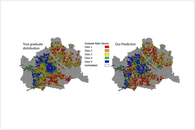
In partnership with colleagues from the Kufstein University of Applied Sciences, researchers of the IC\M/T developed a method based on Artificial Intelligence (AI) to fully automatically extract demographic characteristics from satellite images. More precisely: the proportion of university graduates in a defined area.
The process was tested with several cities in Austria and yielded surprisingly accurate predictions.
What Visual Characteristics Can Tell Us
Matthias Zeppelzauer, Head of the research group Media Computing, and his colleagues of the Kufstein University of Applied Sciences examined the question whether the spacial distribution of university graduates in a city can be predicted on the basis of visual characteristics in satellite images, such as the types of buildings and the vegetation. The researchers’ method was based on Artificial Intelligence techniques.
"AI makes it possible to derive useful data from satellite images and connect them with statistical population data", explains Zeppelzauer. "In more detail, we apply a Convolutional Neural Network (CNN) to a city’s satellite images and thereby predict five density classes of university graduates. Our approach draws on the assumption that satellite images of residential areas contain visual indicators which enable us to predict the proportion of university graduates in a defined residential area."
Furthermore, the research team could use this method to distinguish between populated and unpopulated areas with an impressive accuracy of 96 percent solely based on visual characteristics.
Potential for Urban and Regional Development
The results suggest that AI and machine vision (computer vision) have a high potential for urban and regional economics. Especially in data-poor regions, this approach facilitates demographic analyses.
"We generally see a broad range of possible applications of our predictive model in future research and practice", says Zeppelzauer about the potential of the researchers’ method. "The university graduate ratio is just the first demographic parameter which can be predicted by using satellite images. In future, we want to test other parameters on their predictability. This would allow us to improve future city planning and provide a better basis for designing urban development."

FH-Prof. Priv.-Doz. Dipl.-Ing. Mag. Dr. Matthias Zeppelzauer
Head ofMedia Computing Research Group
Institute of Creative\Media/Technologies Department of Media and Digital Technologies
